Portrait
Up to the beginning of the 20th century, the history of Mitlödi was bound to the location of the village, the South-facing sunny slope, midway between the devasting gullies on the same prehistoric landslide ground like Schwändi and Sool. The Hanslirunse flowed even in 1625 through the Geissgasse. The lining of the Guppenrunse was completed in 1904 after heavy, recurring devastation. Important for the settlement was the drinking water abstraction, as well as at a later date the situation at the bridge. Also, the village is cut in two by the Linth and decays in the village of Ennetlinth on the right bank and the actual village.
The ruins of the castle of Sola is located on a hill north of Sool. It was inhabited in the late 12th and early 13th century and was probably abandoned around 1250. According to Ägidius Tschudi Scriptures "Chronicon Helveticum", however, it was destroyed by the Austrians in 1298, as a possession of the baron Burkhard of Schwanden, together with the castle Benzingen.
According to the Habsburg Urbarium (written around 1300) there were three hamlets in the place of today's village: Obermitlödi (maybe Schwändi), Niedermitlödi and Horgenberg. The monastery stairs remember the time before 1395, when the village had to pay taxes to the Säckingen monastery and the reign of Habsburg: four Malter (mass) of oats and a Malter (mass) of barley, a cow, and if possible at least seven sheep and money.
Mid-15th century, the village sent the only Landammann (mayor) in its history, Konrad Rietler. And 1527 Mitlödi was once Landsgemeindeort (public meeting place where people made public decisions). Mitlödi belonged until 1725 to the Church of Glarus and was mostly Protestant as from 1528 on.
From early on, pillar of the community was the so-called Allmeinden (common land). Establishing so-called Tagwen (cooperatives) had to be particularly important at the constant threat through the gullies and through the flood of the river Linth. Oldest cooperatives are considered to be the Tagwentschachen and the Fadenwald. Seven more Allmeinden were purchased between 1603 and 1785. Until 1769, Mitödi jointly owned groves, goat meadows- and hay rights together with Sool and Schwändi. This is shown today by the so-called Wahltagwen (voting community), which includes all three communities (Mitlödi, Sool and Schwändi), while Mitlödi itself represents a so-called Verwaltungstagwen (administrative community).
1725, the building of an own church was an important cormerstone for the community. The 230 Evangelical Tagwenbürger (citizens with voting power) admitted at that time the right to the 40 less legitimate so-called Hintersassen, to co-decide in church-, education- and poor relief matters. The Catholics remained until 1895 with the parish of Glarus, afterwards they belonged to the Catholic church of Schwanden (since 1951 they have a chapel in Mitlödi).
In the second half of the 18th century, slate table export and cotton wool production led to an economic recovery in the village.
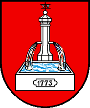
After a fire in the Church, Hans Ulrich Grubenmann built the sleek helmet on the church spire in 1752 and seven years later, one of his masters, built the house for the ship master Fridolin Wild with its decorated paintings at the frontage (Schiffmeisterhaus). A further embellishment of the village brought 1773 the Kirch- or Schäflibrunnen (Church- or sheep fountain), which has become the village coat of arms in 1939.
In 1761 a donation of a school estate was made and as from 1771 the evangelical part of the citizens had its own school, which accepted in 1859 also Catholic children. Around 1800, a Catholic school existed temporarily.
1799 was a really bad year when French and Imperial troups fought in and around Mitlödi. The passage of Suvorov's troups marked this time again. The terrible years after the war, without work and earnings and in difficult climatic conditions until 1816/17, forced to fight poverty with new means. Such learning processes were not without conflicts, as such disputes between Mitlödi and the Evangelical priest Andreas Tschudi shows (in office between 1801-1808).
Some lovely Empire houses of local traders show that conditions had changed around 1830. At this time the village lost its rural appearance. The 1841 generously built old schoolhouse documented the new prosperity and the zeal of the municipality not to lag behind. Middle of the century the population of Mitlödi had risen to about 650.
1856/57 the yasmas textile printing plant Trümpy started its work and offered within 10 year jobs for more than 390 factory workers. After 1893 the plant was converted into a silk printing factory and remained as such - with significant dips after 1930 - until today. However, recently the factory was smartly diversified. The impressive manufacturer castle Waldegg, on the way to Sool, testifies to the power and the self-image of the factory owner around 1900. In the last few decades, more industries have come to Mitlödi. This includes the protochemical industry for pharmaceutical and cosmetic products, a tool and machine factory, a cooking oil factory and a factory which produces radios. Since 1999 also a natural gas line passes to Mitlödi.
New estates in Hinterdorf will ensure that the community with its about 1000 inhabitants must not be concerned about the future.
In 2011, the community structure of canton Glarus was reorganized and Mitlödi became part of the new administrative community Glarus Süd.
Translation of the official website of Mitlödi.

The Baroque Church of Mitlödi
(built 1725)


The cemetery of Mitlödi with Vorder Glärnisch in the background
Family Names from Mitlödi